Analytics Powered Platform
for Date-Palm Health Monitoring
Leverage satellite imagery analytics, IoT soil sensors, and real-time weather reporting to gain actionable insights that optimize irrigation, nutrition, and crop health
Harvest More with Better Quality
Detect plant stress early & act before yield is affected
Optimize Nutrition, Boost Yields
Balance irrigation & fertilization for healthier palms and higher productivity
Work Smarter in the Field
Reduce manual scouting with automated palm health monitoring
Use Less Water, Grow More Dates
Save more water every season using advanced data analysis of soil and weather conditions
Overview
A Closer Look at the Platform
See the key pages of our platform in detail, from farm overview to report generator. Click on any feature to explore how it helps you manage your farm efficiently.
Overview
A Closer Look
at the Platform
See the key pages of our platform in detail, from farm overview to report generator. Understand how each view helps you manage your farm efficiently.
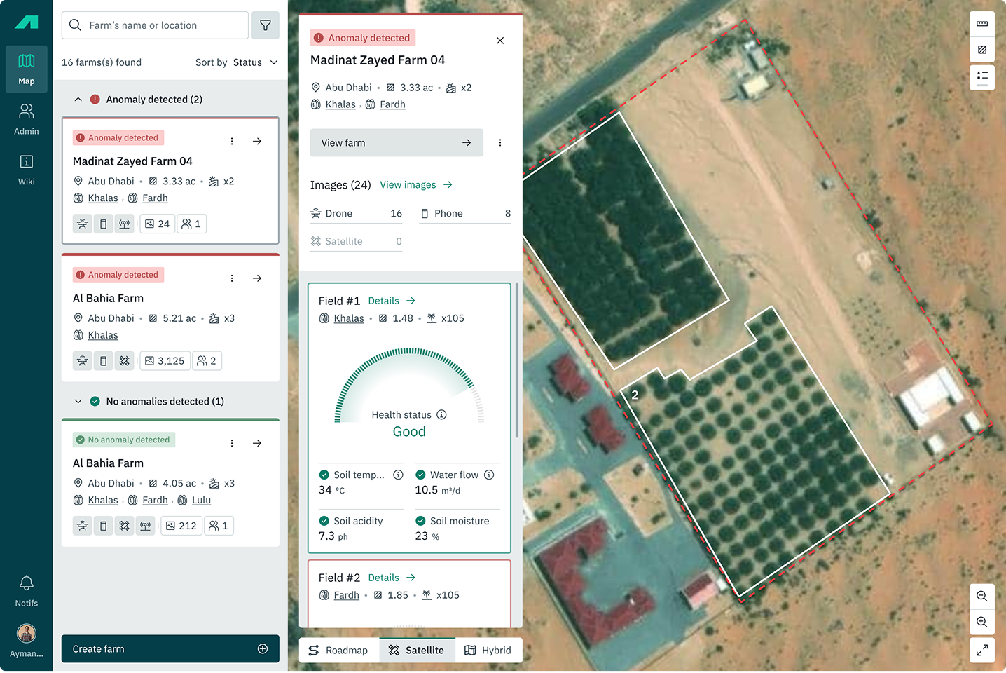
Farms List
Quickly navigate between farms, track detected incidents, and monitor crop health in real time.
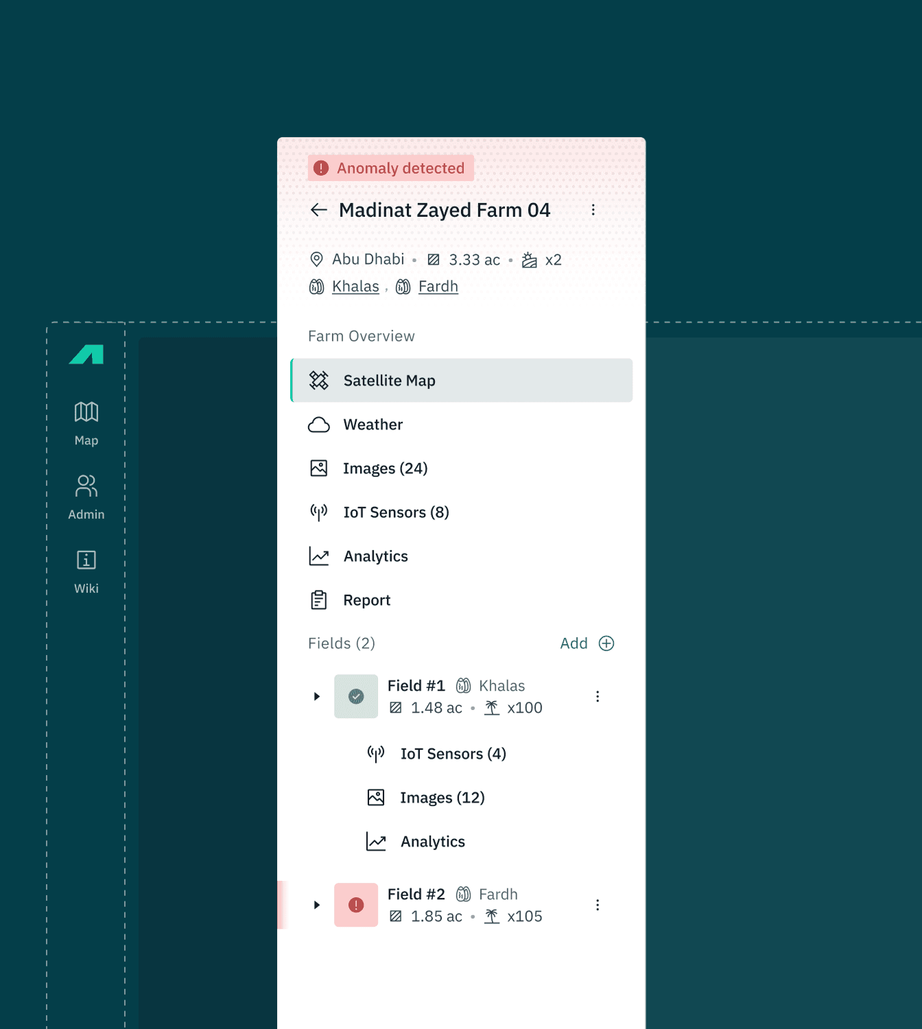
Farm Overview
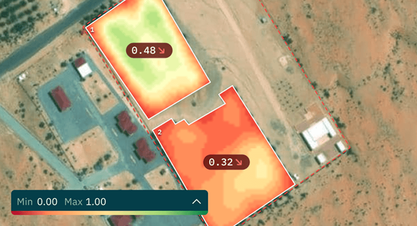
Monitor NDVI trends, crop development stages, and soil conditions — all in one dashboard to make informed agronomic decisions.
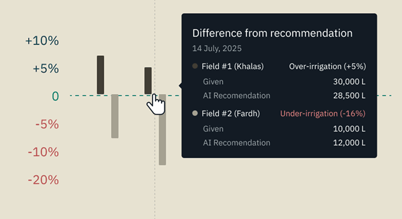
Irrigation Analytics
Analyze irrigation patterns, detect under- or over-watering, and align practices with AI recommendations to improve efficiency.
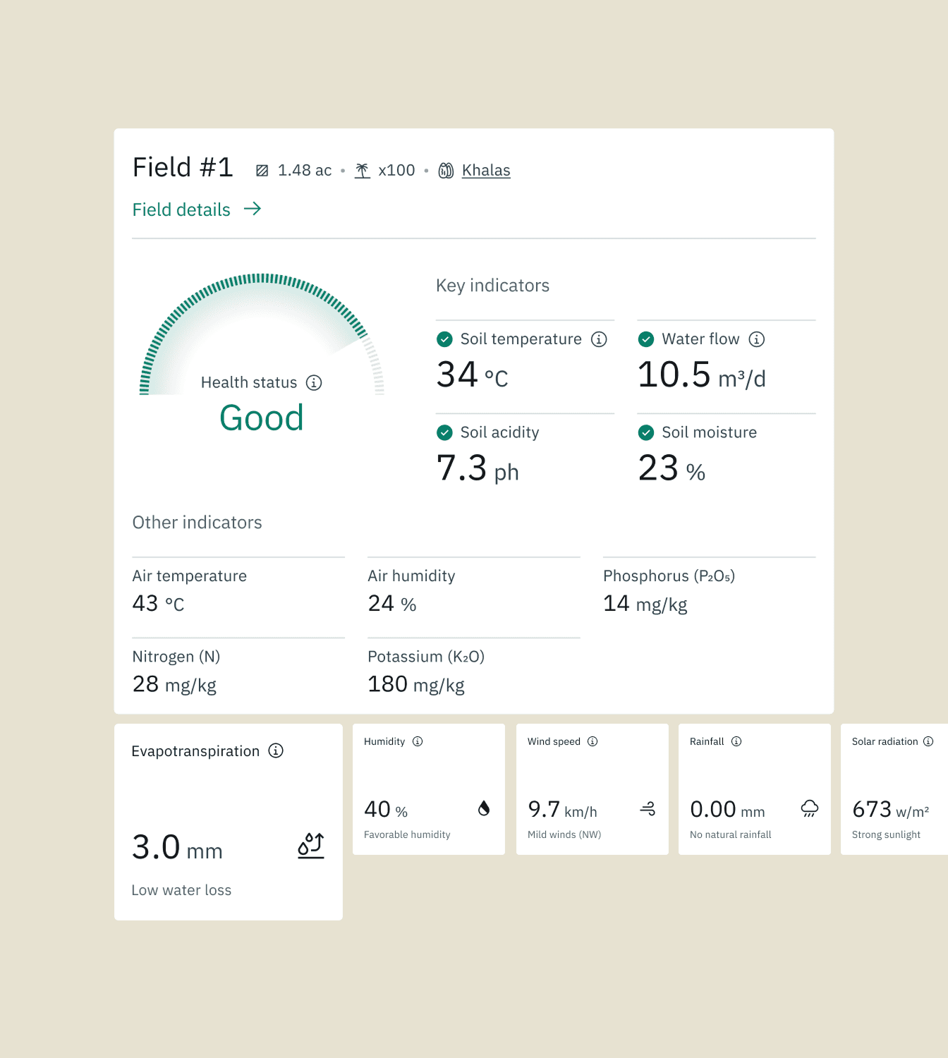
Field Sensors
Real-time insights on soil and environment for smarter water and farm management.
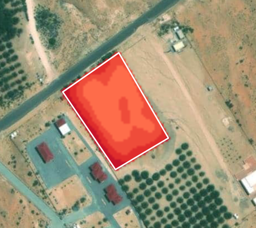
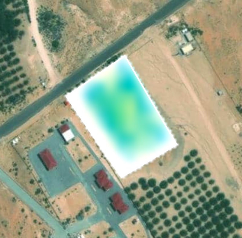
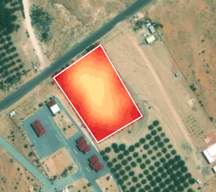
Detailed Image Viewer
Identify stressed or infected trees with AI-powered image analysis, combined with accurate geolocation for targeted intervention.
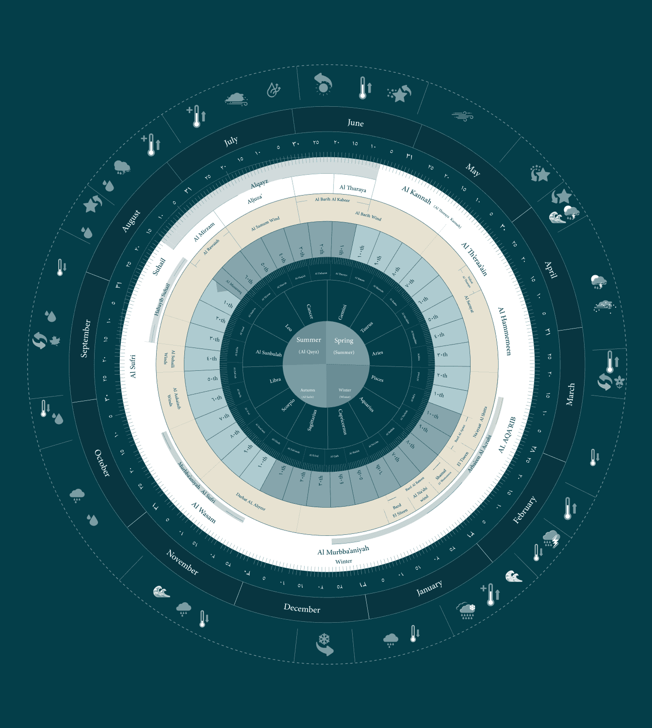
Astro-Agricultural Calendar
Use traditional knowledge and weather patterns to schedule optimal planting, watering, and harvesting times.
Farm Report Generator
Create detailed farm reports in seconds—covering field performance, issues, and trends—ready to share or export.
Admin Panel
Manage users, teams, and access permissions with an intuitive interface — ensuring secure, role-based control across your organization.
Farms List
Quickly navigate between farms, track detected incidents, and monitor crop health in real time.
Farm Overview
Monitor NDVI trends, crop development stages, and soil conditions — all in one dashboard to make informed agronomic decisions.
Irrigation Analytics
Analyze irrigation patterns, detect under- or over-watering, and align practices with AI recommendations to improve efficiency.
Field Sensors
Real-time insights on soil and environment for smarter water and farm management.
Detailed Image Viewer
Identify stressed or infected trees with AI-powered image analysis, combined with accurate geolocation for targeted intervention.
Astro-Agricultural Calendar
Use traditional knowledge and weather patterns to schedule optimal planting, watering, and harvesting times.
Farm Report Generator
Create detailed farm reports in seconds—covering field performance, issues, and trends—ready to share or export.
Admin Panel
Manage users, teams, and access permissions with an intuitive interface — ensuring secure, role-based control across your organization.
How it works?
From Palm to
Excellence: Step by Step
Gather Data
Collect satellite imagery, geotagged mobile photos, IoT sensor readings, and live weather data, covering every palm on your farm.
Gather Data
Collect satellite imagery, geotagged mobile photos, IoT sensor readings, and live weather data, covering every palm on your farm.
Data Processing & Visualization
Turn raw data into clear dashboards and visual maps, showing plant health and water stress.
Data Processing & Visualization
Turn raw data into clear dashboards and visual maps, showing plant health and water stress.
Monitor & Report
Farmers receive clear, easy-to-understand reports with actionable insights, along with interactive dashboards to track results and monthly PDF summaries.
Monitor & Report
Farmers receive clear, easy-to-understand reports with actionable insights, along with interactive dashboards to track results and monthly PDF summaries.
Analyze with Experts
Our specialists analyze the gathered data to estimate water usage, detect plant stress, identify nutrient gaps, and track soil salinity.
Analyze with Experts
Our specialists analyze the gathered data to estimate water usage, detect plant stress, identify nutrient gaps, and track soil salinity.
Designed for Farmers, Built for Clarity: every screen is crafted with agricultural workflows in mind, ensuring intuitive navigation, clear visuals, and quick access to the data that matters most. The platform supports English, Arabic & Urdu making it accessible and practical for diverse farming teams.
Data Sources & Integration
All Your Farm Data,
Unified in One Place
Your farm data whether from satellite images, IoT sensors, weather stations, or manual observations comes together in one easy-to-use hub. No switching between apps, no lost notes.
Meteorological data
Satellite imagery & indices
Field data collection
Unified REST API
With our API you can build custom dashboards, automate reports, or integrate insights directly into your farm ERP or mobile app.
Expert Insights & Analytics
Expert Insights
that Guide Your Farm
Our specialists analyze satellite imagery, weather patterns, and IoT sensor readings to deliver clear reports, yield forecasts, and timely alerts — helping you act before problems affect your palms.
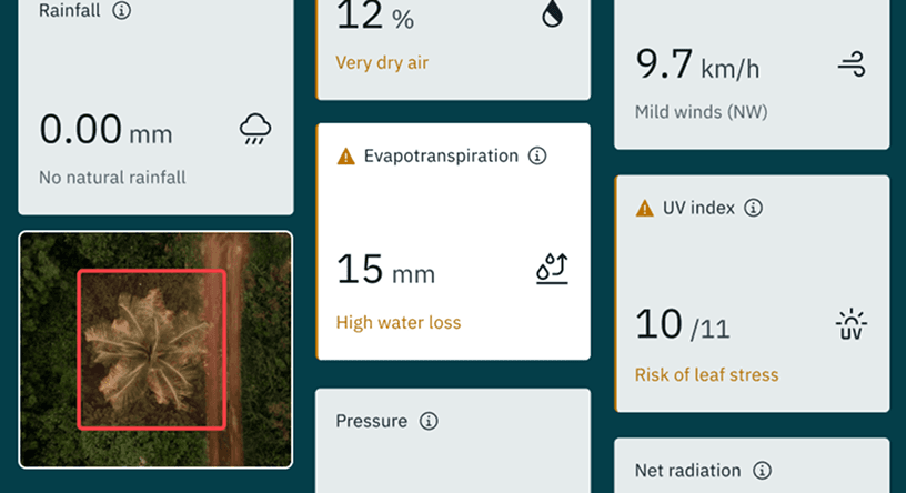
Evapotranspiration estimation
Combines satellite indices, open data, and on-site weather to model ET.
Irrigation scheduling
Adapts watering plans based on rainfall and other weather events.
Plant health scoring
Detects stress, deficiencies, and pest damage from aerial & mobile imagery.
Water-use optimization
Calculates per-palm water needs to maximize yield while minimizing waste.
Alerts & notifications
Threshold-based warnings for salinity, pH, and soil moisture.
Real time data stream
Integrates weather, IoT, and satellite insights for instant, informed decisions.
Cultivar Management
Variety-Specific
Management Aligned
with Local Seasons
Not all palms are the same. Whether you grow Khalas, Lulu or Fardh, our platform adapts schedules to each variety's needs.
Duroor system calendar
Community-tested seasonal calendars for watering, and mobility.
Lifecycle tracking
Record flowering, fruiting, and harvesting timelines for each variety.
Tailored recommendations
Adjust irrigation and nutrient dosing based on each phenology.
Palm variety catalog
Maintain a database of farm-specific cultivars.
Reporting & Deliverables
Insights You Can
Act On
Get the full picture of your farm's performance, on screen or in your inbox. Share reports with your team or partners with one click.
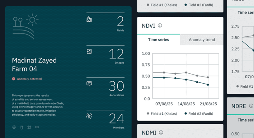
Farm overview reports
Generate detailed farm analytics and performance reports.
Interactive dashboards
Real-time sensor feeds, map overlays, and mobile-friendly data viewer.
API deliverables
Accurate weather reports with accurate forecasting in relation to the farm location.
Farm analytics
Compiled data and analytics from various sensors at your fingertips
Download a sample report to see how insights are structured and shared with your team
Download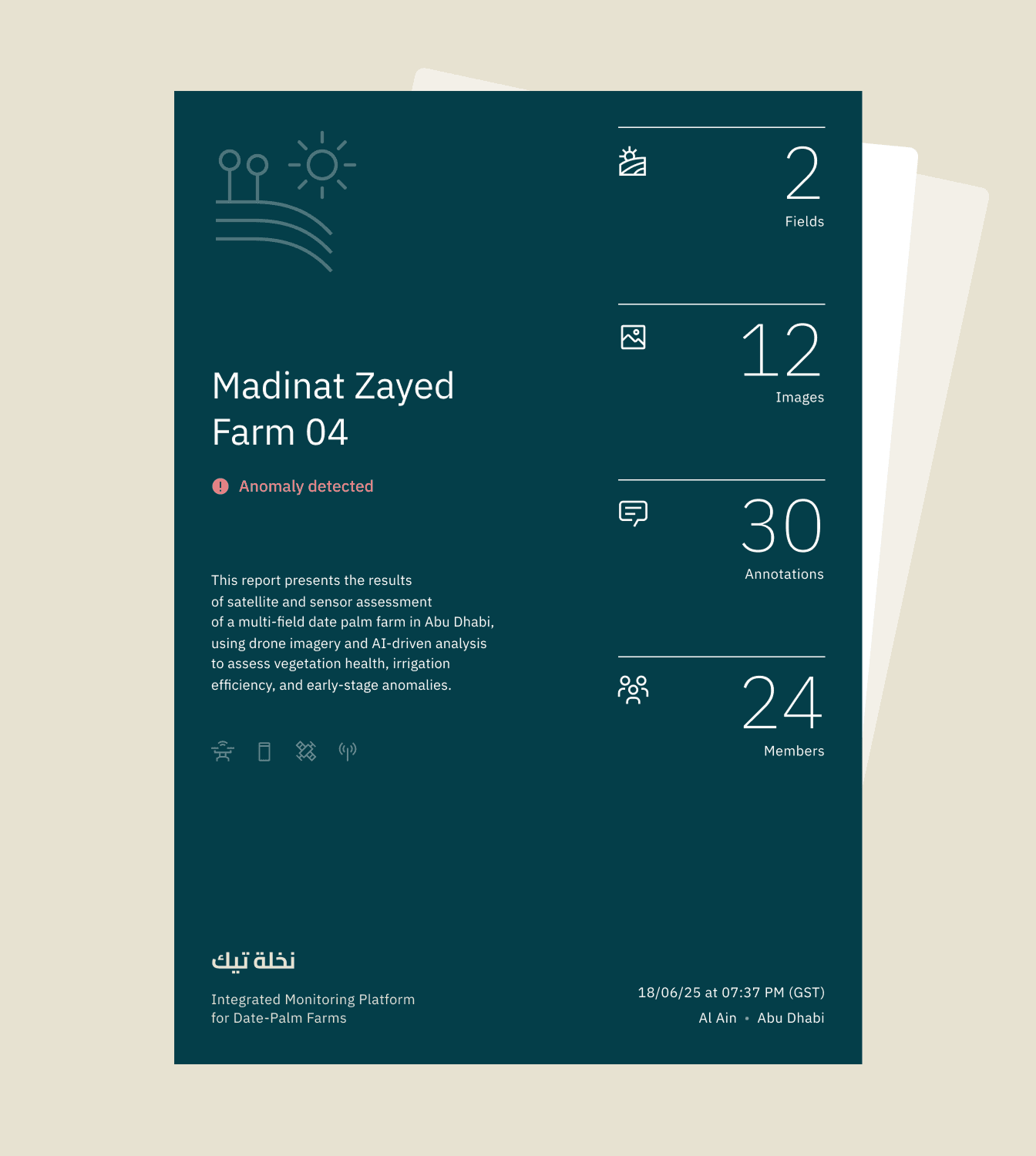
See Your Crops
Like Never Before
Unlock powerful insights with advanced satellite vegetation indices. Our platform gives farmers the ability to monitor crop health, detect issues early, and make data-driven decisions with ease.
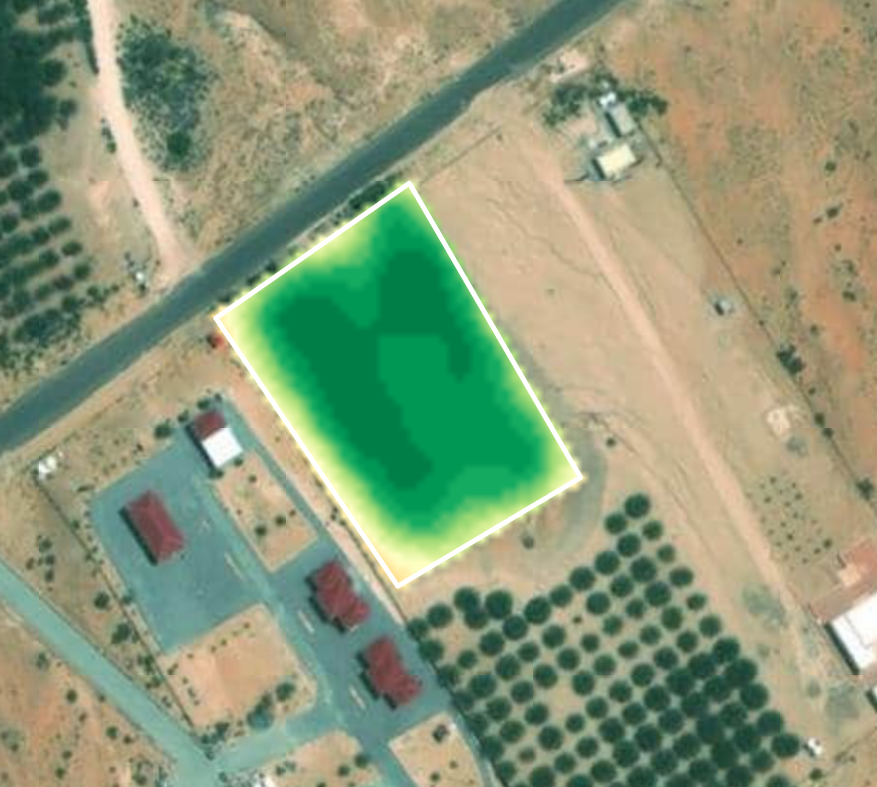
NDVI
Normalized Difference Vegetation Index
Measures vegetation "greenness" and overall plant vitality. Helps detect crop stress, irrigation issues, or disease early.
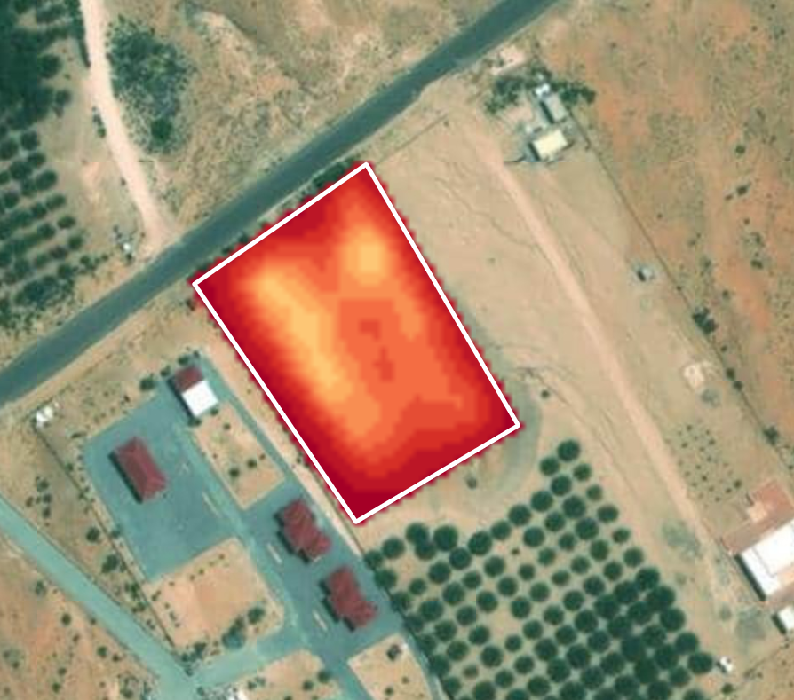
Meta Index
Meta Index
A composite indicator combining multiple vegetation indices to provide a balanced view of crop health and performance.
NDRE
Normalized Difference Red Edge
Focuses on the "red edge" part of the spectrum, sensitive to changes in chlorophyll content. Useful for detecting early crop stress and nutrient deficiencies.
MSAVI
Modified Soil Adjusted Vegetation Index
Reduces the influence of bare soil on vegetation signals. Helps monitor young crops, sparse vegetation, or fields with exposed soil.
RECI
Red Edge Chlorophyll Index
Measures chlorophyll concentration in plants. Provides insights into nutrient status, photosynthetic activity, and overall crop vigor.
IoT Sensors
IoT Sensors for
Precision Agriculture
Gain accurate, real-time field data with advanced IoT sensors.
Renke RS-NPK-TR-EX
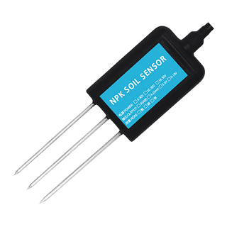
Monitors soil nutrients (Nitrogen, Phosphorus, Potassium) in real time — helps optimize fertilization and avoid overuse.
DFRobot RS485
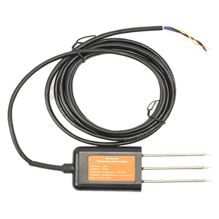
Measures soil moisture and temperature directly in the field — ensures crops get the right amount of water.
IQAir AirVisual Outdoor
Tracks air quality, humidity, and pollution levels — helping to protect crops from harmful environmental stress.
Truflo TK
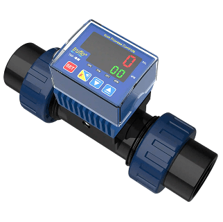
Measures irrigation water flow with high accuracy — prevents overuse, supports efficient water management.
Consulting
Need Expert Advice?
Every farm is different. If you'd like to discuss your challenges, irrigation issues, or crop goals before requesting a demo, our experts are here to help.